Friday, October 13, 2017

Sakawa river

The river at the center of the photo is Sakawa river.Sakawa river lies on the boundary between North American Plate and Philippne Sea Plate,and flows into Pacific ocean at leftside of the center of the photo. Mountains on the other side of the river is Hakone volcano,Matsuda town,Kanagawa Pref.

MinoltaX700 MCrokkor28mm NEOPANACROS100

Tuesday, January 05, 2016

Stone wall of Edo catsle

Since the syogun Ieyasu Tokugawa began to live in Edo catsle in 1590,Edo(Tokyo) has been the metropolitan of Japan practically.Castle that uses many stone walls like this is rare in Japan.These stones are lava of Hakone volcano.  Chiyoda Ward,Tokyo metropolitan


MinoltaX700 MCrokkor28mm NEOPANPRESTO400

Friday, August 28, 2015

Harumi bridge

 
Harumi bridge was costructed over Harumi canal in 1957.Side parts of  the bridge are made of prestressed concrete whitch was new technology in those days.This railroad had gone to the Harumi Wharf,but was abolished in 1989.Harumi Wharf is main wharf of Tokyo,Koto ward,Tokyo metropolis.
 
Fujifilm Tiara2 NEOPANPRESTO400
 

Monday, July 27, 2015

Mt. Tosaka

"Tosaka"means a cockscomb in Japan. It seems the shape of the mountain was made ,because hard dykes in granite have not encroached,Mitomi village,Yamanasi pref.


Kyocerra slimT  NEOPANPRESTO400

Wednesday, August 06, 2014

Akiyamago


Akiyamago is one of the most secluded regions of central Japan.It is said lost samurais migrated to Akiyamago in 12C. In winter several meters of snow fall there,so Akiyamago has been isolated and famine has often occurred,Tsunan town,Niigata pref.


MinoltaX700 rokkor28mm NEOPANPRESTO400

Saturday, June 14, 2014

River terrace of Shinano river

The flat land at the center of the photo is river terrace of Shinano river.The height of the flat land from the bottom of valley is more than 100 meter.Now Shinano river is beyond the flat land and flows from left to right.I think this is the greatest river terrace in Japan,Tsunan town,Niigata pref.


MinoltaX700 rokkor50mm NEOPANPRESTO400


Wednesday, February 26, 2014

Disused railway for transport of silica stone


In Japan natural resources such as wood,mineral and so on had been transported by railway until 1960's.We can see such disused railway in the depth of mountains,Mitomi village,Yamanashi pref.

Kyocerra slimT NEOPANPRESTO400

Monday, August 12, 2013

Mt. Yakedake reflected on surface of Taisyo pond

Mt. Yakedake is a new volcano.Now its activity is stopped.But in1915 it erupted and mud flow dammed Azusa river and Taisyo pond was made.We can see trace of debris flow on the surface of water,Martsumoto city,Nagano pref.


MinoltaX700 NEOPANPRESTO400

Tuesday, June 11, 2013

Debris flow occured slope

In 2011.6 debris flow occuered at some place in Kamikochi,central Japan.I think the debris flow occuered because clacks in bedrock opened by megaquake in 2011.3.11,Matsumoto city ,Nagano pref.

MinoltaX500 rokkor28mm NEOPANPRESTO400


Sunday, April 14, 2013

Larch forest in autumn 

In cold district,larch trees were planted for their fast grouth in Japan. Larch tree is deciduous and coniferous tree.Yellow leaves in autumn and spring greenery of larch trees is very beautiful. Nagawa villege,Nagano pref.


Fujifilm tiara NEOPANPRESTO400

Monday, March 25, 2013

Reedy marshe at Tega pond

Tega pond is one of large ponds around Tokyo.At Tega pond reedy marsh extends like this photogrph.Reedy marshe is helpful for purification of water quality and formation of soil.

But after the nuclear power plant accident of Fukushima 1,the region around Tega pond was contaminated hard by radioactivity.And radioactive substances are flowing into Tega pond . Living thing will be received a bad influence from the radioactivity.I hope all nuclear power plant  disappear on earth! Kashiwa city,Chiba pref.


Konica C35 NEOPANPRESTO400


Monday, January 14, 2013

Old sabo-dam made from rubble

We can see old sabo-dam in mountain region all around Japan.After World War 2 many parts of mountain region were ruined in Japan.So,the Forestry Agency of Japan carried out afforestation project.In the project many dam like this photo were constructed.By such dams,movement of soil and sand was stopped and vegetation of forests recovered.,Nagawa village,Nagano pref.


Fujifilm tiara NEOPANPRESTO400


Friday, September 07, 2012

Kar at Kamikochi

Getting off a bus at Kamikochi bus stop,we can see kar topography before us.It is situated southern slope of Mt.Hotaka.Last stage of Pleistocene several glaciers existed in Japan.Now we can see glacial topography like kar mainly at Japanese Alps,Matsumoto city,Nagano pref. 

Fujifilm tiara NEOPANPRESTO400

Wednesday, August 01, 2012

Rice terraces in winter


Usually there is no rice field on mountain in Japan.But we can see it on mountain where tertiary mudstone exists,because mudstone changes to clay there.Sometimes landslide occurs on rice terrace,Tokamachi city,Niigta pref.

kyocerra slimT NEOPANPRESTO400


Wednesday, April 18, 2012

Rice terraces in winter


Usually there is no rice field on mountain in Japan.But we can see it on mountain where tertiary mudstone exists,because mudstone changes to clay there.Sometimes landslide occurs on rice terrace,Tokamachi city,Niigta pref.

kyocerra slimT NEOPANPRESTO400


Friday, March 23, 2012

Fuji river

  
The moutain in the photo is Mt,Fuji.The town on the other side of the river is Fuji city.There is an an active fault along the river and the land on this side of the river rises every time earthquake occurs..So the height of Fuji city is lower than Fuji river.This fault is the boundary of Eurasian plate and Philippine sea plate,Fuji city,Shizuoka pref.

FUJICAGS645 NEOPAPRESTO400


Friday, February 17, 2012

Kandagawa bridge


Kandagawa bridge is the railway bridge across Kanda river constructed in 1932.It has chracteristic pier seen in the photo.Kandagawa bridge is thought as the symbol of Akihabara,Chiyoda ward,Tokyo metropolis.


kyocerra slimT NEOPANPRESTO400  


Thursday, October 13, 2011

River terrace around Shinano river

Shinano river is the longest river in Japan.Around Shinano river we can see many terraces.It is said that Shinano Rever Terraces has the largest scale in Japan,Tokamachi city,Niigata pref.

kyocerra slimT NEOPANPRESTO400  

Monday, September 12, 2011

Columnar joint

This rock is laver that flowed over ten million years ago.Columnar joint was made by reduction of laver volume,as it become cool.Tokamachi city,Niigata pref.


kyocerra slimT NEOPANPRESTO400


Wednesday, July 27, 2011

Summer at Tega pond

Tega pond is a large pond in north-west part of Chiba pref. It was a part of inland sea about 6000 years ago when climate was warmer than now.Tega pond is called "EAST KAMAKURA"because of it's beautiful scenery,Abiko city,Chiba pref.


FUJICAGS645 NEOPANPRESTO400


Wednesday, July 06, 2011

Wingnut tree "Pterocarya rhoifolia"

Pterocarya rhoifolia grow along stream in cool-temperate zone forest.It grows to 30-40m tall.
Genus Pterocarya is distributed in east and west Asia. I guess ancestor of them lived around north pole in early Cenozoic.Yuzawa town,Niigata pref.


Kyocerra slimT NEOPANPRESTO400


Monday, May 30, 2011

Nakatsugawa canyon


About fifty thausands years ago,Naeba volcano erupted and volcanic lava and ash flowed.After that stream of Nakatsugawa eroded the lava and ash and this canyon was made.We can see a bed of lava in the cliff on the opposite side of the river.Tsunan town.Niigata pref.

Kyocerra slimT NEOPANPRESTO400

Monday, February 14, 2011

Beech tree at Mt. Tsukuba

Mt. Tsukuba is isolated mountain in Kanto plain.In Kanto plain evergreen broad-leaved trees grow.But we can see beech trees at the top of Mt. Tsukuba,because climate is cool there.
Tsukuba city,Ibaragi pref.
 

FUJIKAGS645 NEOPANACROSS100 


Sunday, January 09, 2011

Hijiri bridge

Hijiri bride is constructed in 1927.This bridge is one of eariest concrete arch bidges in Japan.The river in the photo is Kanda river ,which was built for defense of Edo castle in 17C.

Chiyoda ward ,Tokyo Metroporis

FUJIKAGS645 NEOPANACROSS100

Saturday, January 01, 2011

Discontinued logging railroad

In 1975 all logging railroad were discotinued in Japan.But we can see left rail in some place,Otaki village,Saitama pref.

Kyocerra slimT NEOPANPRESTO400


Sunday, December 12, 2010

Kachidoki bridge


Kachidoki bridge was built over Sumida river in 1940.It connects Ginza and Harumi  wharf.
Kachidoki bridge is bascule bridge and it is the longest bridge of all movable bridges in Japan.
Chuo ward ,Tokyo Metroporis

FUJIKAGS645 NEOPANACROSS100  


Friday, October 29, 2010

Sumida river

Sumida river is the most representative river in eastern part of Tokyo.Asakusa,Taito ward,Tokyo Metropolis.

Fujica GS645 NEOPANACROS100  


Friday, October 01, 2010

Keta river

Hamamatsu city,Shizuoka pref.

Kyocerra slimT NEOPANPRESTO400


Monday, August 16, 2010

Hisuikyo

Hisuikyo is ravine along Hida river.Hisuikyo mainly consists of chart.This chart diposited on deap sea floor of ancient Pacific ocean in Mesozoic.   Hichiso town,Gifu pref.

Kyocerra slimT Konicaminoltapan400


Sunday, June 13, 2010

Yotagiri river

   Yotagiri river flows from Central Japan Alps.Central Japan Alps is rising most heavily in Japan,   so a lot of stones flow out.Most of stones is granite.Komagane city,Nagano pref.

FUJICAGS645 EBCFUJINON45mm NEOPANACROS100 MICRODOR-X


Tuesday, May 11, 2010

River in the past

Kokai river was short-cut artificially at Ryugasaki city.The part that is left is pond now.Lotus is cultivated there.Ryugasaki city,Ibaragi pref.

FUJICAGS645 EBCFUJINON45mm NEOPANACROS100 MICRODOR-X

Sunday, March 07, 2010

Blue face vajra

We can see this stone statue at a crossroads in farm of Chiba pref.

Asahi city ,Chiba pref.


RICOHGR10 NEOPANACROS 100

Tuesday, February 16, 2010

Beech forest in spring

Genus Fagus was distributed continuously along medium latitude in ancient times.But now we can see it only at Japan ,north america ,Europe.
It is considered because of drying of climate.Mt Takahara,Yaita city,Tochigi pref.


FUJICAGS645 EBCFUJINON45mm NEOPANACROS100 MICRODOR-X

Friday, February 05, 2010

Inba pond


Inba pond is situated at the northwest part of Chiba pref.This pond was sea B.C. A part of the pond was reclaimed in 20C.Inba village,Chiba pref.

RICOHGR10 NEOPANACROS100

Monday, January 18, 2010

A house on mountainside

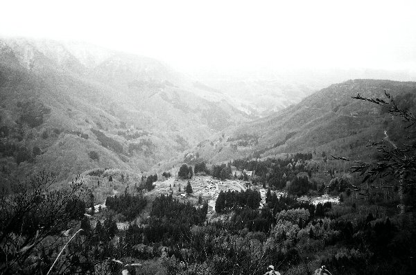
Houses are scattered on mountainside along Tenryu river.Loud voice seems to reach the house on the other side of the valley.Around the houses, tea is cultivated.
Tstsuyama villege,Sizuoka pref.

RICOH GR10 NEOPANACROS100

Friday, January 08, 2010

Tsubaki sea


This field had been vast bay or lake until Edo period(17C).The lake became rice field by reclamation.
Asahi city,Chiba pref.

RICOHGR10 NEOPANACROSS100


Thursday, December 24, 2009

Byobugaura


At Byobugaura strata of Pleistocene continue more than 10km.In Japan we can rarely see landscape like this because of strong diastrophism.Cyosi city ,Chiba Pref.

FUJICAGS645 EBCFUJINON45mm NEOPANACROS100 MICRODOR-X

Saturday, December 19, 2009

Mt.Komochi


Mt.Komochi had been in activity 0.9-0.2 million years ago.
We can see dikes around the top of the mountain,which radiate in all directions,Shibukawa city,Gunma pref.

There are many volcanos in the center of Gunma pref.

MinoltaX700 rokkor28mm
Konicaminoltapan400


Thursday, December 17, 2009

Dam Reservoir on the Tenryu River

This reservoir appeared by construction of Funagira dam on the Tenryu River.Tenryu River has five dams,and Funagira dam is situated at the lowest reach of the five dams.

Recently all of these dams is filled up with gravel and sand,Hamamatsu city,Sizuoka pref.

RICOHGR10 NEOPANACROSS100


Friday, December 11, 2009

Alder trees


Alder trees grow on wetland.
We can often see alder trees at moutain streem,too.

Tone river,Toride city,Ibaragi pref.

Fujica GS645 EBCfujinon45mm
NEOPANACROS100 Microdor-x


Tuesday, November 10, 2009

Moonrise at Tega pond


Kasiwa city ,Chiba pref.

Fujifilm finepixf30


Tuesday, October 13, 2009

Morning at Kofu Basin


Kofu Basin is surrounded by  mountains.
But the basin is flat,because stone and sand flowed from surrounding mountain accumulated on the bottom of the pool.Kofu city,Yamanashi pref.

RICOHGR10 NEOPANACROS100


Monday, October 12, 2009

River terrace and alluvial fan

The rice field is on the river terrace of Tenryu river.The easy slope seen at the center of the photo is alluvial fan.
This fan is made of stone and sand that flowed from mountain(Central Japan Alps),Komagane city,Nagano pref.

FUJIKAGS645 EBCfujinon45mm NEOPANACROS100 Microfine


landscape of Japan

Friday, October 02, 2009

Green tea farm on slope of mountain

Along Tenryuu river we can see green tea farm.Cultivation of tea is main industry ,because no flatland there.
Tatsuyama village,Sizuoka pref.

RICOHGR10 NEOPANACROSS100


landscape of Japan

Sunday, September 27, 2009

Welded tuff

On the left bank of Tone river we can see vertical cliff.This is welded tuff from the volcano Mt.Akagi,Shibukawa city,Guma pref.

MimoltaX700 rokkor28mm Konicaminoltpan400 D76


Saturday, September 12, 2009

Ota ,post-town on Nakasendo

Nakasendo was main route from Edo to Kyoto in Edo period(17-19C).
We can see old guest houses on both sides of the street,Minokamo city,Gifu pref.

Kyocerra slimT Konicaminoltapan400 D76


landscape of Japan

Monday, August 31, 2009

Mt.Suzugatake


Suzugatake is a parasitic volcano of Mt.Akagi,Sibukawa city,Gunma pref.

MimoltaX700 rokkor28mm Konicaminoltpan400 D76


Monday, July 20, 2009

Pacific ocean seen from Byobugaura 


Byobugaura is called Dover of Orient.
Cyosi city ,Chiba Pref.

FUJICAGS645 EBCFUJINON45mm NEOPANACROS100 MICRODOR-X

Sunday, July 12, 2009

Meeting house in mountain village

This village is situated on the slope of valleyside of Tenryu river.
This village is in depopulated area ,and no children lives here.

The swing and slide in the photo will be never used forever.

Tatsuyama village ,Sizuoka Pref.

RICOHGR10 NEOPANACROS100


Sunday, June 28, 2009

Idzura seashore


Idzura seashore is situated at
northernmost of Kanto area,along Pacific ocean.
This is sea cliff that consists of Tertiary rock.
Kitaibaragi city,Ibaragi Pref.

MinoltaX700 MCrokkor28mm NEOPANACROS100