Tuesday, October 13, 2009

Morning at Kofu Basin


Kofu Basin is surrounded by  mountains.
But the basin is flat,because stone and sand flowed from surrounding mountain accumulated on the bottom of the pool.Kofu city,Yamanashi pref.

RICOHGR10 NEOPANACROS100


Monday, October 12, 2009

River terrace and alluvial fan

The rice field is on the river terrace of Tenryu river.The easy slope seen at the center of the photo is alluvial fan.
This fan is made of stone and sand that flowed from mountain(Central Japan Alps),Komagane city,Nagano pref.

FUJIKAGS645 EBCfujinon45mm NEOPANACROS100 Microfine


landscape of Japan

Friday, October 02, 2009

Green tea farm on slope of mountain

Along Tenryuu river we can see green tea farm.Cultivation of tea is main industry ,because no flatland there.
Tatsuyama village,Sizuoka pref.

RICOHGR10 NEOPANACROSS100


landscape of Japan

Sunday, September 27, 2009

Welded tuff

On the left bank of Tone river we can see vertical cliff.This is welded tuff from the volcano Mt.Akagi,Shibukawa city,Guma pref.

MimoltaX700 rokkor28mm Konicaminoltpan400 D76


Saturday, September 12, 2009

Ota ,post-town on Nakasendo

Nakasendo was main route from Edo to Kyoto in Edo period(17-19C).
We can see old guest houses on both sides of the street,Minokamo city,Gifu pref.

Kyocerra slimT Konicaminoltapan400 D76


landscape of Japan

Monday, August 31, 2009

Mt.Suzugatake


Suzugatake is a parasitic volcano of Mt.Akagi,Sibukawa city,Gunma pref.

MimoltaX700 rokkor28mm Konicaminoltpan400 D76


Monday, July 20, 2009

Pacific ocean seen from Byobugaura 


Byobugaura is called Dover of Orient.
Cyosi city ,Chiba Pref.

FUJICAGS645 EBCFUJINON45mm NEOPANACROS100 MICRODOR-X

Sunday, July 12, 2009

Meeting house in mountain village

This village is situated on the slope of valleyside of Tenryu river.
This village is in depopulated area ,and no children lives here.

The swing and slide in the photo will be never used forever.

Tatsuyama village ,Sizuoka Pref.

RICOHGR10 NEOPANACROS100


Sunday, June 28, 2009

Idzura seashore


Idzura seashore is situated at
northernmost of Kanto area,along Pacific ocean.
This is sea cliff that consists of Tertiary rock.
Kitaibaragi city,Ibaragi Pref.

MinoltaX700 MCrokkor28mm NEOPANACROS100 


Tuesday, June 23, 2009

Alternation of sandstone and mudstone


The alternation is deposit of debris flow on deep see floor.
Mt Kiyosumi,Amatsukominato town,Chiba Pref.


MinoltaSR101 rokkor28mm PLUS-X


landscape of Japan

Friday, June 19, 2009

Sugao pond


Sugao pond is one of prominent wetlands in Japan.Bando city,Ibaragi Pref.

Frexaret3 mirar80mm NEOPANACROS100

Saturday, June 13, 2009

Horizontal line seen from Tukuba mountainous region

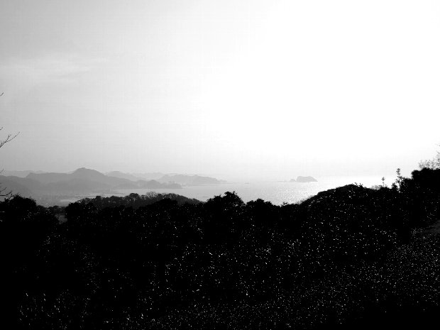
This is horizontal line of Pacific ocean.
Ishioka city,Ibaragi Pref.

MinoltaX700 rokkor28mm NEOPANACROS100
   landscape of Japan

Monday, June 08, 2009

National road 418

The part of route 418 along Kiso river is too narrow to pass for car.
Yaotsu town,gifu pref.

MinoltaSR101 rokkor28mm PLUS-X

Sunday, May 31, 2009

Tega river


Tega pond is situated near the center of Kanto plain.The east half of Tega pond was reclaimed after world war 2,and only a river remains now. It had been in sea until middle ages.
Kasiwa city,Chiba Pref.

Flexaret3 miror80mm NEOPANACROS100

Friday, May 15, 2009

Yashiki-grove


In the Kanto plains Japanese Zelcova (Ulmaceae tree) and other trees are planted around farmhouse for protection against the wind,Souka city,Saitama Pref.


MinoltaSR101 ROKKOR28mm TRI-X

Tuesday, April 21, 2009

Trace of debris flow


Debris flow often occurs in Japan,because rock in Japan is very weak by geological activity.
Debris flow is called "snake-pass",for it seems as if snake is going.

Oto town ,Mie pref.

RICOHGR10 NEOPANACROSS100

Sunday, March 08, 2009

Onaruto bridge


This bridge was built between Shikoku and Awaji island.Tidal current flowed from left to right this day.We can often see swirl here.
Naruto city,Tokushima Pref.

kyocerra slimT NEOPANACROSS100

Sunday, January 18, 2009

Hackberry trees on riverbed


Kokai river,Toride city,Ibaragi pref.
2008.5

MinoltaX700 rokkor28mm NEOPANACROSS100

Monday, January 05, 2009

Vegetation of mt. Takahara


This is forest on volcanic slope of mt.Takahara.Tall trees are hardwood (white birch,cherry,etc.).Short trees are fir.Fir trees will replace hardwoods.

Yaita city,Tochigi pref.

Minolta X700 rokkor28mm NEOPANACROSS100

Friday, December 26, 2008

Mt.Takahara


Mt. Takahara is a mountain in northern Tochigi prefecture, which stopped it's volcanic activity about 0.1 million years ago .

Valley of the photo is former crater.


Obsidian is yielded in Mt. Takahara. At Kenngamine in left part of the photo, a old stone age mine of obsidian has been found .

Stone tools made of obsidian yielded in Mt. Takahara are found in many parts of the Kanto area.

Minolta X700 NEOPANACROSS100
日本語
>
英語
言語の入れ替え
翻訳

Tuesday, August 12, 2008

Floodplain forest of Tone river


Most of those trees are hackberry trees. These trees were planted.,Toride city,Ibaragi Pref.

RICHOGR10 NEOPANACROSS100

Friday, July 18, 2008

Bato Kannon(stone statue)


This statue was put along old road in Edo period(18~19C),for a memorial service for horses that carried people and load,Cyosi city ,Chiba Pref.,central Japan.
RICHO GR10 NEOPANACROSS100

Thursday, June 05, 2008

Villege on mountainside


The geology of this villege is shist.Shist is apt to change to clay,so landslide occurs in moutainside like this villege.On lindslide people can cultivate soil easily.
Koyadaira villege,Tokushina Pref.,southwest Japan
kyocerra SlimT NEOPANACROSS100

Saturday, May 17, 2008

Ravine made by encroachment of river


This river has encroached on weak rock(green shist)for a long time,so the ravine like this has been made.We can see wide river terrace on both side of the river. Oto town,Mie Pref. central Japan
RICHO GR10 NEOPANACROSS100

Saturday, May 03, 2008

A deserted house in moutain villege


Recently many sucessors of family in Japanese mountain villege migrate to city.So we can see deserted houses like this photograph,Koyadaira villege ,Tokusiha Pref.
kyocerra slimT NEOPANPRESTO400

Thursday, January 03, 2008

afforested trees in valley

Posted by Picasa


This is forest of cryptomeria.This forest is well cared.We can see Cryptomeria only in east Asia and Japan.Cryptomeria is old plant that appeared on earth in Mesozoic.Cryptomeria belongs to the same class of Sequoia in America,Ome city,Tokyo Metropolis
RichoGR10 NEOPANACROSS100

Monday, August 27, 2007

HOTA coast in winter

HOTA is situated in south part of Boso peninsula.It's climate is rather warm.The sea lefthand is Tokyo bay,Kyonan town,Chiba Pref.Fujica GS645 NEOPNPRESTO400(original print)

Sunday, July 08, 2007

Heizaura


Heizaura is shore situated at the south end of Boso peninsula. Boso peninsula has rised upward since early Tertiarry.Heizaura rised more than 5m in 1703 when strong earthquake occured.Tateyama city,Chiba Pref.Kyocerra slimT NEOPNPRESTO400

Sunday, May 20, 2007

Floodplain forest along Kokai river


Zelkova ,hackberry tree etc. can be seen ,Toride city ,Ibaragi Pref. kyocerra slimT konicaminoltapan400

Thursday, May 10, 2007

Mt.Fuji seen from Lake Motosu


This scene has been used as the design of 5000-yen bill.The plain beyond the lake is made of pyroclastic material from Mt. Fuji(volcano),Fujikawagutiko town,Yamanashi Pref . Kyocerra Slim T NEOPNACROSS100

Sunday, February 25, 2007

Tokyo bay seen from Boso peninsula


The south half of Boso peninsula is situated in low latitude area,so its climate is rather mild. Kyonan town,Chiba Pref. Fujifilm finepixf30

Saturday, January 20, 2007

Mini-folding

This cobble was transported by water from highland which is 
called SOUTH JAPAN ALPS. The pattern on the surface of the rock was made by high temperature and pressure that was generated as PHILIPPIN SEA PLATE subducted under JAPAN. HAYAKAWA town,YAMANASI Pref. Kyocerra SlimT NEOPANACSOSS100                                       

Thursday, January 04, 2007

Rock Sea


These small rocks were seperated from mountain by freeze and melt of glacier for the glacial period.This topography is called "Rock Sea",Sensui pass,Yamanasi Pref.  Kyocerra SlimT tessar 35mm NeopanPRESTO1600

Sunday, September 10, 2006

Rice field in spring

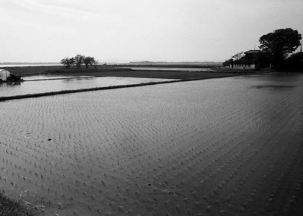
rice field after rice planting,Kasumigaura,Ibaragi Pref. MinltaX700 rokkor28mm konicaminoltapan400

Wednesday, August 30, 2006

UENO STATION

UENO STATION is one of main terminal stations in Tokyo. Most trains for northeast Japan leave from this station,Tokyo,Japan. Flexaret3 Mirar80mm Tri-x

Thursday, July 20, 2006

THE NIPPON RHEIN


This is Kiso river(木曽川)in the middle reach.
Kiso river near hear is called "THE NIPPON RHEIN".This is named by SIGETAKA SIGA(志賀重昂)japanese geographer,because it looks like the RHEIN river in Germany.
The mountain at the center of the photograph is Mt. Hatohuki(鳩吹山),the symbol of Minokamo city(美濃加茂市),Gifu Pref.

ASAHIPENTAX SP takmar 20mm konicaminoltapan400

Thursday, May 25, 2006

Japan ceders afforested

These trees are Japan ceders(Cryptomeria japonica)afforested and well kept,so they have grown straight upward. Mizunami City、Gifu Pref.


ASAHI PENTAX SP 20mm konicaminoltapan400 Posted by Picasa

Tuesday, April 25, 2006

Container liner running in rice field

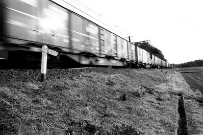
This train goes for Tokyo from Kashima(鹿島) port on Narita line.
Narita city 、Chiba Pref.


MinoltaSR101 rokkor28mm Konicaminoltapan400 Posted by Picasa

Sunday, April 23, 2006

morning field

Vapor over a field,Mitake town(御嵩町),Gifu Pref.

Minolta SR101 rokkor28mm PLUS-X Posted by Picasa

Wednesday, April 12, 2006

Hukazawakyo

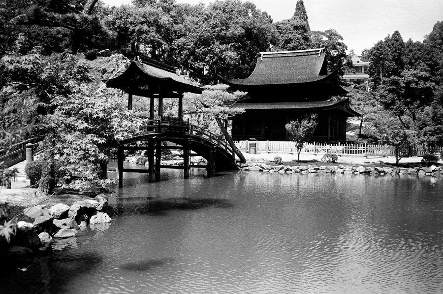
Hukazawakyo(深沢峡) is a  ravine in the middle reach of Kiso River(木曽川).This is far from main route、so few people visit there. Gifu Pref、central Japan.
Minolta SR101 rokkor28mm Konicaminoltapan400  Posted by Picasa

Friday, March 31, 2006

Tega Pond in autumn


Eastern half of Tega pond(手賀沼) had been reclaimed till 1965 since 17C. It looks like river now. Abiko city(我孫子市),Chiba Pref.   MinoltaSR101 rokkor28mm konicaminoltapan400                          

Tuesday, February 28, 2006

Rice field in autumn


Rice field after harvest in October、 Gifu Pref. central Japan     MinoltaSR101 rokkor28mm konicaminoltapan400                    

Thursday, February 16, 2006

A jetliner and crown of trees


Narita airport is situated in countryside、and surrounded by rice field and forest.               MinoltaSR101 rokkor28mm Konicaminoltapan400                               

Sunday, January 29, 2006

Japanese garden in temple of Zen


This is garden in Eihoji(永保寺)、temple of Zen(禅).It was planned by Muso Soseki(夢窓疎石)、a priest of Zen in 14C.   Tajimi city(多治見市)、Gifu Pref.               Kyocerra slim T zeiss 35mm Konicaminoltapan400 

Sunday, January 15, 2006

Stratified chart

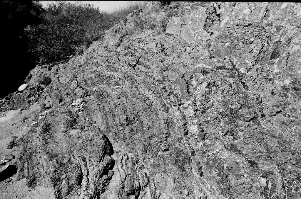
Stratified chart This rock was deposited on bottom of deep sea(old Pacific)in Mesozoic about one hundred million years ago.  Minokamo city ,Gifu Pref.     ASAHI PENTAX SP Takmar 20mm Konicaminoltapan400